


Camera tour
Price: Free
Time to visit a place: 120 phút
Open Time: 7:00 AM - Close Time: 6:00 PM
Address: Hung Phu Village, Hung Nguyen District, Nghe An Province
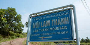
LAM THANH MOUNTAIN
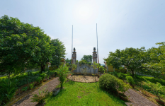
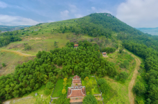
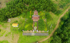
Lam Thanh mountain in Hung Phu commune, Hung Nguyen district, Nghe An province, known by many different names: Thanh hill, Dong Tru Son, Hung Son mountain, Nghia Liet mountain. Because the mountain is close to Lam River, there is a citadel on the mountain (Truong Phu citadel), so it is called Lam Thanh mountain.
According to geological survey documents, Lam Thanh mountain was formed by the process of stratigraphic tectonics along with the Truong Son range and some other mountains. Lam Thanh Mountain stands out in the middle of a rich and vast plain, surrounded by magnificent mountain ranges: Dai Hai mountain in the north, Hong Linh range shields the South, the West is embraced by Thien Nhan mountain; In front, close to the foot of the mountain is the confluence of rivers, the confluence of two large rivers: Lam River and La River. The river is meandering, the mountain chooses its back, charming landscape of river and mountain is rare to find, making Lam Thanh to be a famous scenic spot in Nghe An, the subject of many famous poets and painters such as King Le Thanh Tong, Bui Duong Lich composed...
Historically, Lam Thanh mountain is the place to mark many important historical events of the locality and nation. With a strategic location near the river, leaning against the mountains, surrounded by rich villages, during the period of building and defending the country, Lam Thanh always kept a strategic position. Especially in the resistance war against the Minh invaders, Lam Thanh was the place that marked the most important historical events.
Since the Minh Dynasty sent 200,000 troops to invade our country in 1406, Lam Thanh mountain had been occupied. The Minh army built on this mountain a system of strong ramparts as a place to station troops, projecting all directions from the inside out, the outside in and including the vast plains of Nghe An, Ha Tinh.
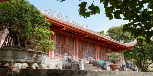
In 1413, Lam Thanh mountain marked the event that Governor Nguyen Bieu (highest official overseeing the affairs of the court) was sent by Emperor Trung Quang to be a missionary, and entered Truong Phu's palace to negotiate but failed. The heroic sacrifice of Nguyen Bieu is a symbol of the indomitable spirit of the nation. To remember the merits of Nguyen Bieu, the People built his temple on Lam Thanh mountain, called An Quoc temple (Yen Quoc) and Nguyen Bieu temple at the foot of the mountain..
During the resistance war against the Minh army of Le Loi, Nghe An was chosen as the base of the insurgent army. Lam Thanh continued to be an important military point that both Lam Son insurgents and Minh troops had the determination to fight and keep. While the Lam Son insurgent force was growing stronger, the Minh army in Nghe An citadel was increasingly isolated. In February 1427, the Minh army general who kept Nghe An citadel named Thai Phuc, before a letter of persuasion from Nguyen Trai, opened the citadel gate to surrender and contributed many plans for Le Loi to fight the Minh army. After his death when returning home, Le Loi mourned, named him Tuyen Nghia marquis and assigned the people of Lam Thanh area to build Tuyen Nghia temple at the foot of Lam Thanh mountain to commemorate his merits. Over 2 years of construction, forces in Lam Thanh area became a solid rear, Le Loi recruited and trained insurgents to form a powerful army strong enough to besiege and destroy the Minh army in Nghe An and and march to the North, completely liberating the country.
Towards the end of the 18th century, Nghe An citadel on Lam Thanh mountain was the place where King Quang Trung - Nguyen Hue met with La Son Nguyen Thiep to discuss strategies to fight the Thanh army. Before pulling his army to the North, King Quang Trung held a grand parade at Lam Thanh mountain.
It can be said that Lam Thanh mountain is the place to mark many important historical events associated with the nation's thousands of years of anti-foreign invasion history. During 370 years, from the beginning of the post-Le Dynasty (1428) to the end of the Tay Son Dynasty (1801), Lam Thanh was also the town of Nghe An. With those historical values, Lam Thanh mountain was classified as a national historical-cultural relic by Ministry of Culture and Information in Decision No. 313/QD-VH, dated May 19, 1962.
Distance: 8.19 km
Distance: 9.62 km
Distance: 9.96 km
Distance: 10.41 km
Distance: 10.63 km
Distance: 10.76 km
Distance: 10.76 km
Distance: 10.91 km
Distance: 11.03 km
Distance: 11.06 km
Distance: 11.18 km
Distance: 11.30 km
Distance: 11.31 km
Distance: 11.31 km
Distance: 11.33 km
Distance: 11.58 km
Distance: 11.82 km
Distance: 11.95 km
Distance: 4.11 km
Distance: 10.31 km
Distance: 10.50 km
Distance: 10.55 km
Distance: 10.99 km
Distance: 11.16 km
Distance: 11.16 km
Distance: 11.49 km
Distance: 11.99 km
Distance: 12 km
Distance: 12.04 km
Distance: 12.11 km
Distance: 12.14 km
Distance: 12.24 km
Distance: 12.28 km
Distance: 12.32 km
Distance: 12.48 km
Distance: 12.51 km
Distance: 0 m
Distance: 290 m
Distance: 1.82 km
Distance: 1.82 km
Distance: 1.82 km
Distance: 4.64 km
Distance: 5.89 km
Distance: 7.58 km
Distance: 9.31 km
Distance: 9.32 km
Distance: 9.89 km
Distance: 10.30 km
Distance: 10.35 km
Distance: 10.43 km
Distance: 10.44 km
Distance: 10.73 km
Distance: 10.77 km
Distance: 10.97 km
Distance: 10.99 km
Distance: 11.50 km
Distance: 11.55 km
Distance: 11.57 km
Distance: 11.61 km
Distance: 11.65 km
Distance: 11.96 km
Distance: 11.98 km
Distance: 12.06 km
Distance: 12.21 km
Distance: 12.21 km
Distance: 12.22 km
Distance: 12.24 km
Distance: 12.27 km
Distance: 12.37 km
Distance: 12.38 km
Distance: 12.55 km


0
No Comment!